Any natural water stream originating from mountains, hills, glaciers, lakes, springs or other water bodies or another water flow, flowing naturally between the two banks falling into a sea, ocean, lake, water body or another water flow is river (National River Conservation Committee 2022).
River System of Bangladesh
A river system is a group of rivers discharging water by way of a common flow or system of channels into a sea or a lake. Basically, the river system contributes towards flood control and the total drainage system networks of a country. River systems do not only connect both the physiography and the lives of the people but also provide fish, the main water source for irrigation, transport facilities, and the maintenance of ecological balance. Moreover, this system served to replenish the fertile agricultural land with to replenish the fertile agricultural land with fresh deposits of rich silt and carry an enormous volume of sediments (almost 2.4 billion tonnes) to the Bay of Bengal. Actually, the river system is the country’s principal resource and the cause of its greatest hazards as well.
Predominantly the River system of Bangladesh has four major networks:
1. Brahmaputra-Jamuma River system
2. Ganges-Padma River System
3. Surma-Meghna River System, and
4. Chittagong Region River System
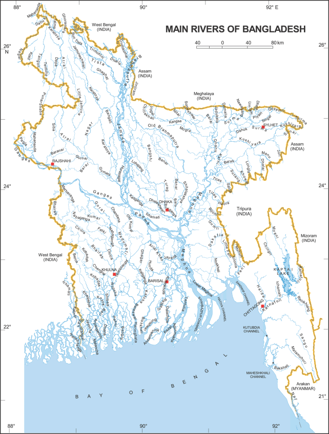
Figure: Main Rivers in Bangladesh (Cook et al., 2019)
1. Brahmaputra-Jamuna River system
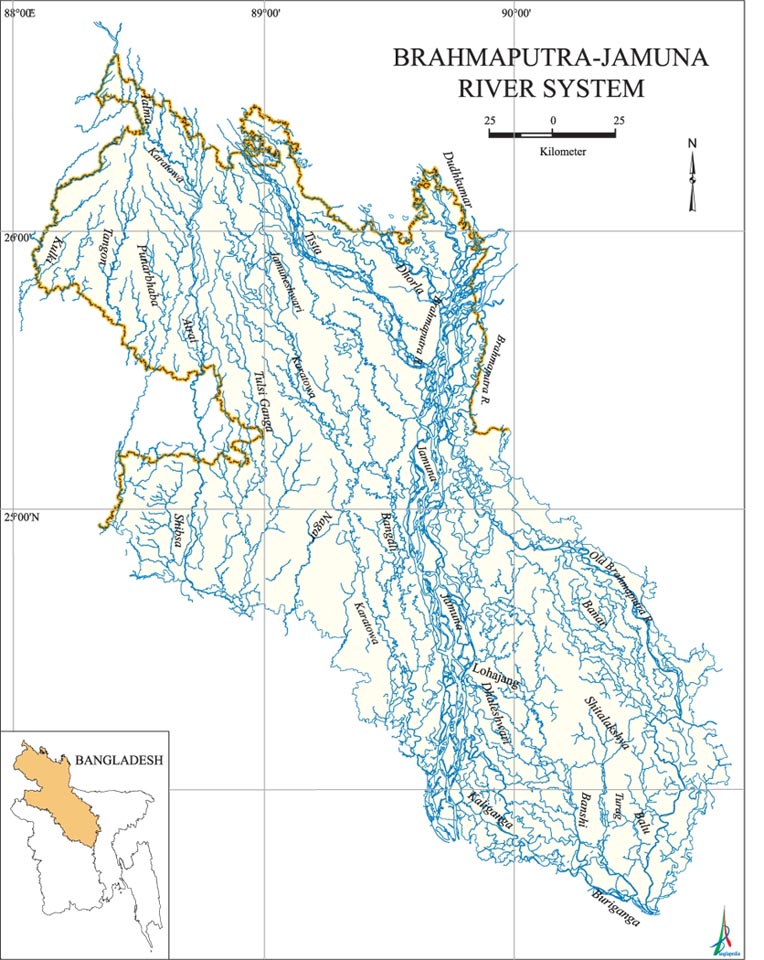
This is 292 kilometres long and flows from northern Bangladesh to its confluence with the Padma. It originates from China’s Xizang Autonomous Region (Tibet) and flows through India’s state of Arunachal Pradesh (AP). In Arunachal Pradesh, it becomes known as the Brahmaputra, which means ‘Son of Brahma’. It enters Bangladesh through Kurigram district. At the point where the Brahmaputra meets with Tista, it becomes the Jamuna River, and Jamuna meets Padma at Goalanda. It has four major tributaries: the Dharla, Dudhkumar, Tista, and Karatoya-Atrai systems. During the monsoon, this river system discharges a large volume of water and, at the same time, brings in a huge amount of sediment.
2. Ganges-Padma River System
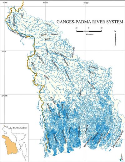
This river system originated from the Gangoutri glacier in the Uttarakhand Province (UP) of India. It covers a total length of about 2,600 kilometres, along with Bangladesh. Ganges-Padma is divided into two sections: first, the Ganges (258 km long), starting from the western border of Bangladesh with India to its confluence with the Jamuna at Goalandaghat in Rajbari district. And about 120 km long, Padma is recognised as the second one flowing up from Goalondoghat to Chandpur, where it joins the Meghna. The rivers like Kumar, Chitra, Madhumati, Nabaganga, Arial Khan, Rupsha, and Bishkali are some of the numerous streams in the south-east direction of the Ganges delta fed by the Ganges-Padma spillage.
3. Surma-Meghna River System
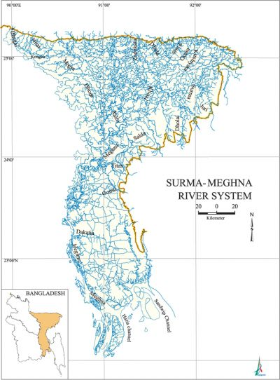
The third network of the river system of Bangladesh is the Surma-Meghna System, which is the longest river in Bangladesh as well as the largest on earth, fanning out to the Bay of Bengal. The length of this system is a total of 946 km, or 669 km within Bangladesh. The river is also the widest among the rivers in Bangladesh. It rises in the hills of Shillong and Meghalaya in India as the Barak River. Before entering Bangladesh, the Barak River divides into two attributes: the northern confluence is Surma, and the southern point is Kushiara. The Meghna receives the old Brahmputra on its right at Bhairab Bazar. Several small channels branching off from the Meghna and enduring through the lowland boarding the Tippera Surface receive the flow of a number of hilly streams such as Gumti, Kakrai, Hawrah, Sonaiburi, and Dakatia tributaries. The most important of these offshoots is the Titas.
4. Chittagong Region River System
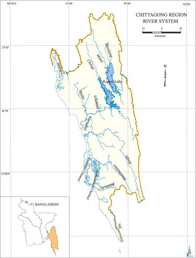
The channel networking of the Chittagong Region River System is unconnected to the other three river systems due to its distinctive geographical feature. So, this system is different from the other three river systems. Flowing through the region of Chittagong and the Chittagong hills, it cuts across the hills and runs rapidly downhill to the west and southwest and then to the sea. The Feni, Muhuri, Bakkali, Naaf, Karnaphuli, Sangu, and Matamuhuri are the main rivers of this region. The total length of this system is about 420 kilometres. The port of Chittagong is situated on the banks of the Karnaphuli. This river was dammed upstream at Kaptai for a water reservoir that is used for the generation of hydroelectric power. These rivers and streams, however, represent the Chittagong region as one of the most intensive natural sites and incredible ecological biodiversities in the world. According to its geographic position and biodiversity, the river has vibrant potential as well as jeopardy and hazards. Actually, this mighty network of four river systems flowing through the Bangladesh plain drains an area of some 1.5 million square kilometers. In the monsoon period, the rivers of Bangladesh flow at about 140,000 cubic metres per second, and during the dry season, the flow diminishes to 7,000 cubic metres per second.
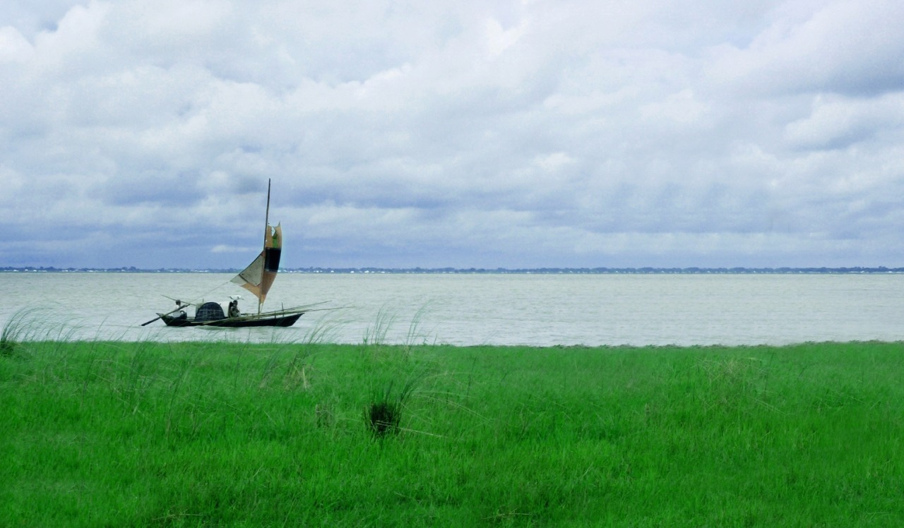
Figure: Padma River (bdbangladesh.tumblr.com)
List of all rivers in Bangladesh: Click here to the list
For more details about the fish biodiversity of Rivers of Bangladesh follow the following references:
The Checklist of the Riverine Fishes of Bangladesh
References
- Banglapedia (2024) River System of Bangladesh. [Accessed on 19 August, 2024] https://en.banglapedia.org/index.php/River_and_Drainage_System
- Cook AD, Foo YN (2019) Towards ‘shared’and ‘complex’disaster governance in Bangladesh: The 2017 Rohingya exodus. International Journal of Disaster Risk Reduction, 39, 101233
- Hossain MAR, Wahab MA, Belton B (2012) The checklist of the riverine fishes of Bangladesh. The world Fish Center, Bangladesh and South Asia Office, Dhaka
- Uddin MJ, Jeong YK (2021) Urban river pollution in Bangladesh during last 40 years: potential public health and ecological risk, present policy, and future prospects toward smart water management. Heliyon, 7(2)