A beel is a term that denotes a lake-like wetland with static water (as opposed to moving water in rivers and canals – typically called khaals), in the Ganges – Brahmaputra – Meghna flood plains of Bangladesh. In other words, Beel is a large surface waterbody that accumulates surface runoff water through internal drainage channels; these depressions are mostly topographic lows produced by erosions and are seen all over Bangladesh. Beels are small, saucer-like depressions of a marshy character. Many of the beels dry up in the winter, but during the rains, they expand into broad and shallow sheets of water, which may be described as fresh water lagoons.
Formation of Beel:
Beels can be formed due to many causes. In some cases, a string of them is found along a line of drainage, suggesting that they are the remains of some great river that centuries ago deserted its channel in favour of a new one somewhere else. In other cases, they are probably due to the action of rivers, which, through centuries of silt deposits, have raised their beds and marginal banks so high that they flow above the level of the surrounding area. The land between a pair of parallel rivers thus forms a kind of trough in between. The rivers, on the other hand, cannot overflow their banks into these depressions (during normal floods) as they themselves are locked within their channels by high levees.
Beels are mainly fed by surface runoff water. A few larger ones are fed by floodwater during the wet season from the parent river channel. Normally, beels remain deeply flooded for most of the wet season and the rims are primarily used for either boro cultivation or deepwater rice. Beels are important wetlands and regarded as valuable fish and wildlife habitat.
Beels in Bangladesh at a glance:
Bangladesh has a significantly vast number of beels in all over the country, except in the hill tracts in the south eastern part. In the active floodplains of the Surma-Meghna, the Brahmaputra-Jamuna, and the Ganges-Padma river systems, there are several large and small beels. In Bangladesh, there are thousands of beels of different sizes.
It is reported that there are 6300 beels in the Haor districts (Sunamganj, Sylhet, Habiganj, Maulavibazar, Netrakona, Kishoreganj & Barhmanbaria) alone. They are of varying sizes, out of which about 3,500 are permanent and 2,800 are seasonal. Considering the unique hydrological characteristics of floodplains and haor region, this Annexure has been divided in two parts.
A. Beels of Flood Plains and
B. Beels of Haor Districts
List of all Beels in Bangladesh: Click here on the link
Chalan Beel
Chalan Beel is one of the largest inland depressions of marshy character and also one of the richest wetland areas in Bangladesh. It is the largest beel and most important watershed in north-central Bangladesh and covers an area of about 375 km2 during the monsoon season. The average depth of more than 2 m during dry season and more than 4 m at rainy season.
The watershed serves about 5 million people, predominantly through fisheries and agricultural activities. The Chalan beel area incorporates 21 rivers and 93 smaller seasonal beels of varying sizes.
Location
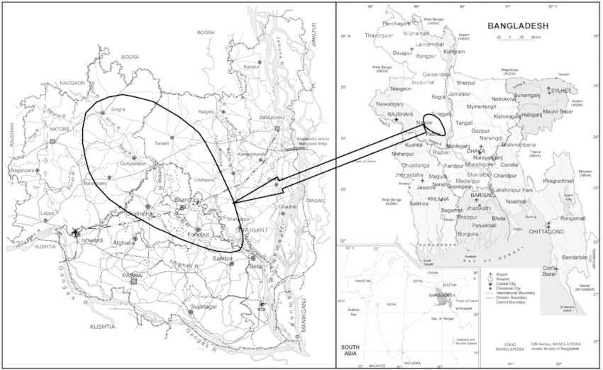
Figure 1: Location of Chalan Beel (Hossain et al., 2009)
It is located between 24.35 to 24.700 north latitude and 89.10 to 89.350 east longitudes. It covers an area belonging to Singra, Grudashpur and Boraigram upazila of Natore district, Chatmohar upazila of Pabna district, Tarash, Roygonj and Ullapara upazila of Sirajgonj district and Ahasanganj and Manda Upazila of Noagaon district. The greatest breadth and length of the beel is about 13 km and 24 km respectively.
History of Formation (Chalan Beel)
Chalan Beel was formed when the old Brahmaputra diverted its water into the new channel of the Jamuna. Chalan Beel was probably a backswamp before it was greatly expanded with the inclusion of abandoned courses of the Karatoya and the Atrai and became a vast lake. The formation of the Chalan Beel is historically linked with the demise of the Atrai and the Baral. The Atrai, or Gur, was the principal feeder channel of Chalan beel, which used to drain the districts of Dinajpur and northern Rajshahi. The baral worked as an outlet for the beel and eventually found its way into the Jamuna. It was about 1,088 square kilometres in area at the time it was formed.
Fisheries Resources
A total of 81 fish species, including 72 indigenous and 9 exotic, were recorded under 12 fish orders, 27 families, and 59 genera. The most abundant fish species are punti (Puntius sophore and Puntius ticto), followed by chanda (Chanda nama and Parambassis ranga), chapila (Gudusia chapra), and tengra (Mystus vittatus). A total of 12 types of fishing nets, 5 types of fishing traps, 6 types of hooks and lines, and 4 types of wounding fishing gear were found (Galib et al., 2009).
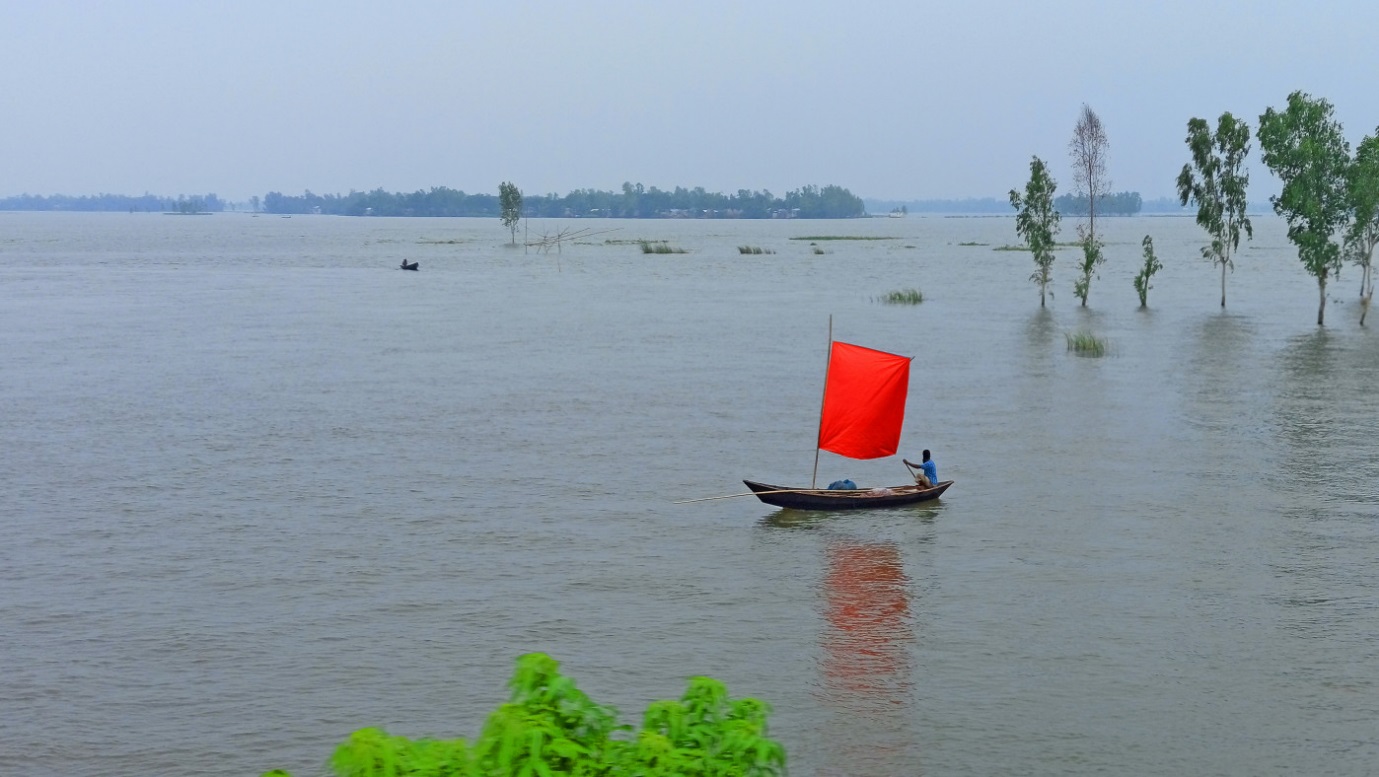
Figure 2: Chalan Beel (tbsnews.net)
For more details about the biodiversity of Chalan Beel follow the following references:
- Assessment of fish fauna in relation to biodiversity indices of Chalan Beel, Bangladesh
- Investigation on species composition in Chalan beel of Bangladesh
- Biodiversity and conservation status of Chalan Beel in northern Bangladesh: A study
- Present Status of Fishes in the Chalan Beel-The Largest Beel (Wetland) Of Bangladesh
- Fish Diversity of Chalan Beel in Relation to Fish Sanctuary
- An Enquiry on Ichthyodiversity of the Chalan Beel, A Key Ichthyofaunal Hotspot of Northwestern Bangladesh
Although considerably degraded over time, the beels of Bangladesh still support a diverse ichthyofauna of major importance to the local economy and people’s livelihoods. Most of the beels are at risk of partial or total degradation as a result of agricultural encroachment, siltation, and other anthropogenic activities.
References:
- Chowdhury GW, Sarker N, Akash M, Latifa GA (2017) An enquiry on ichthyodiversity of the Chalan beel, a key ichthyofaunal hotspot of northwestern Bangladesh. Ecoprint: An International Journal of Ecology, 24, 37-46
- Galib SM, Samad MA, Mohsin ABM, Flowra FA, Alam MT (2009) Present status of fishes in the Chalan Beel-the largest beel (wetland) of Bangladesh. International Journal of Animal and Fisheries Science, 2(3), 214-218
- Galib SM, Samad MA, Mohsin ABM, Flowra FA, Alam MT (2009) Present status of fishes in the Chalan Beel-the largest beel (wetland) of Bangladesh. International Journal of Animal and Fisheries Science, 2(3), 214-218
- Hossain MA, Nahiduzzaman M, Sayeed MA, Azim ME, Wahab MA, Olin PG (2009) The Chalan beel in Bangladesh: Habitat and biodiversity degradation, and implications for future management. Lakes & Reservoirs: Research & Management, 14(1), 3-19
- Karim SR, Halim KA, Uddin MA, Yeasmin MF, Hasanuzzaman K (2020) Investigation on species composition in Chalan beel of Bangladesh. International Journal of Fisheries and Aquatic Studies, 8(6), 88-91
- Khanom DA, Shikha S, Hossain MD, Joadder AR (2022) Fish diversity of Chalan Beel in relation to fish sanctuary. Journal of Bio-Science, 30(1), 61-68
- Rahman MH, Al-Amin SSM, Zaman A (2022) Biodiversity and conservation status of Chalan Beel in northern Bangladesh: A study. International Journal of Fisheries and Aquatic Research, 7(2), 30-38
- Siddique MAB, Hussain MA, Flowra FA, Alam MM (2016) Assessment of fish fauna in relation to biodiversity indices of Chalan Beel, Bangladesh. International Journal of Aquatic Biology, 4(5), 345-352