Haors are bowl-shaped depressions of considerable aerial extent lying between the natural levees of rivers or highlands in the northeastern region of Bangladesh. In most cases, haors have formed as a result of peripheral faulting leading to the depression of haor areas (BHWDB, 2012). There are 373 Haors in Bangladesh, as identified in the “Master Plan of Haor Area” (BHWDB, 2012).
The term “Haor” was originally derived from the Sanskrit word “Shagor,” which means “sea.” The key trait of Haors is that they flood every year during the rainy season. Haors are technically depressed and marshy lands that are nearly circular in form. A haor is a wetland habitat in Bangladesh’s north-eastern region that is geographically a shallow depression in the form of a bowl or saucer, also known as a back swamp.
Haors, with their unique hydro-ecological characteristics, are large bowl-shaped floodplain depressions located in the north-eastern region of Bangladesh, covering about 1.99 million ha (19,998 sq km) of area and accommodating about 19.37 million people. There are 373 haors located in the districts of Sunamganj, Sylhet, Habiganj, Maulvibazar, Netrakona, Kishoreganj, and Brahmanbaria. These 373 ha cover an area of about 859,000 ha, which is around 43% of the total area of the haor districts. It is a mosaic of wetland habitats, including rivers, streams, canals, large areas of seasonally flooded cultivated plains, and beels.
The following table gives the number of haor with areas in the seven haor districts, while the figure shows the haor location and system in the northeast region of Bangladesh.
Table: Haor regions in Bangladesh
| District | Total Area in ha. | Haor Area in ha. | No. of Haors |
| Sunamganj | 367,000 | 268,531 | 95 |
| Sylhet | 349,000 | 189,909 | 105 |
| Habiganj | 263,700 | 109,514 | 14 |
| Maulvibazar | 279,900 | 47,602 | 3 |
| Netrakona | 274,400 | 79,345 | 52 |
| Kishoreganj | 273,100 | 133,943 | 97 |
| Brahmanbaria | 192,700 | 29,616 | 7 |
| Total | 1,999,800 | 858,460 | 373 |
Source: Master Plan of Haor Area (BHWDB, 2012)
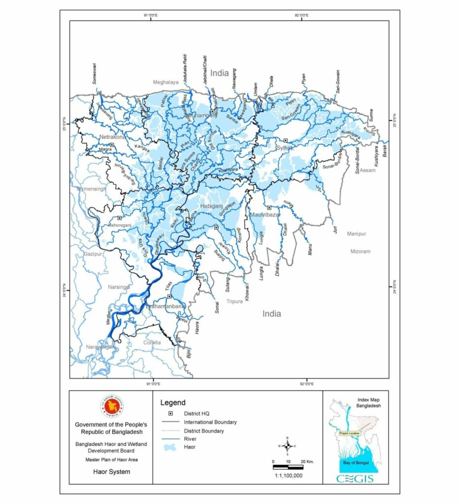
Figure 1: Haor of north-east region of Bangladesh (BHWDB, 2012)
List of all haors in Bangladesh: Click here to see the list
Flora and Fauna
Through gradual sedimentation from the tributaries of the Meghna River, the Haor basin has become shallower and more fertile. As a result, various wetland plants like reeds and sedges grow, which provide food and shelter for fish and other aquatic fauna, resulting in a vast variety of wetland biodiversity. Due to continuous submergence, wetland habitat is characterised by anaerobic conditions that inhibit normal plant growth, apart from a group of plants known as hydrophytes. Flood-tolerant plant species like the hijal or hual, korij or koroch, bhui dumur, nol, khagra, ban golap, and barun are mainly found in the swamp forests.
One of the most important features of the Haor Region is that it is a sanctuary for both permanent and migratory birds. A large variety of small fish, oysters, water snails, bivalves, and pasture spread over the surface, attracting a large number of migratory birds. They use the Haor basin as their resting and roosting ground, attracting tourists from all over the country and thus making the Haor region a popular tourist spot. According to the “Maser Plan of the Haor Area,” about 208 species of birds live or visit Bangladesh. Among the birds, 30% are waterfowl, 26% are waders, 20% are bush and her bland birds, and the rest are grassland and air-hawking prey. Of these freshwater birds, 129 species (62.3%) are resident, and the others are migratory.
Haors are rich in aquatic biodiversity, particularly in diverse fish species. The Haor region comprises a wide variety of finfish, including 143 indigenous and 12 exotic species, along with several species of freshwater prawns (BHWDB, 2012).
Both Hakaluki Haor and Tanguar Haor were designated an Ecologically Critical Area (ECA). It is also a protected Ramsar site of international importance for the conservation and sustainable utilization of wetlands.
Hakaluki Haor
Location
Hakaluki Haor is situated in the eastern part of Bangladesh, adjacent to the Assam-Bangladesh border. Five upzillas comprise this haor’s total area. Three of them, Kulaura, Juri, and Baralekha, are in Moulvibazar district. While the other two upzillas, Golapganj and Fenchuganj, are under the Sylhet division. It covers a large surface area of about 181.15 km2 and around 40% of this area is in Baralekha Upzilla. This huge land coverage makes it Bangladesh’s largest haor and one of Asia’s largest wetlands.
![Figure 1. Map of the studied Hakaluki haor area in Barlekha upazila, Moulvibazar, Bangladesh [Source: Map drawn under Community-Based Wetlands Biodiversity Management Program (CWBMP) by the CNRS GIS unit, Dhaka].](https://freshwaterbiodiversity.org.bd/wp-content/uploads/2024/08/figure-1-map-of-the-studied-hakaluki-haor-area-in.png)
Figure 2: Hakaluki Haor (Shahidullah et al.,2016)
Wetlands
There are more than 238 interconnected beels, some perennial and others seasonal. During the dry season, about 4,400 ha are covered by the beel, but in the summer rains, the area floods to about 18,383 ha and remains underwater for up to five months. During this period, all the beels unite into one large lake, making Hakaluki Haor the largest freshwater wetland in Bangladesh. The haor is mainly fed by the Juri/Kantinala, Sonai/Bordol, Damai/Fanai, and Kuiachara Rivers.
Biodiversity
A total of 558 species of animals and birds have been identified in Hakaluki Haor. Amphibians, reptiles, aves, and mammals all enrich the biodiversity of this region. These include freshwater turtles and tortoises, otters, capped langurs, Pallas’s Fish Eagles, dolphins, snakes, and more. A total 83 species of fishes in the haor have been recorded belonging to 55 genera, 28 families and 10 orders (Iqbal et al., 2015). Hakaluki Haor is especially significant for bird lovers, with 417 species of aves spotted here, including 26 that are totally threatened, 2 vulnerable, 10 endangered, and 14 critically endangered. Many migratory birds visit the area in the winter, with their numbers increasing every year, making Hakaluki Haor a significant bird-watching site. The wide variety of waterfowl is one of the main attractions.
Figure 3: Hakaluki Haor (wikimedia)
Tanguar Haor
Location
Tanguar Haor, a large haor in Sunamganj district, spans 10 mauzas in Dharmapasha and Tahirpur upazilas. These mauzas are Jagadishpur, Bhabanipur, Lamagaon, Ramsinhapur, Mahajampur, Maindag, Mayajuri, Bhangachara Purba, Noagaon, and Tanguar Haor. The haor contains 120 beels of various sizes and covers about 100 sq km, including 46 villages.
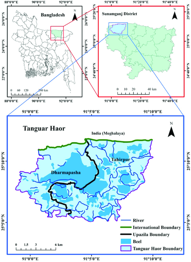
Figure 4: Tanguar Haor (Sultana et al., 2022)
Biodiversity
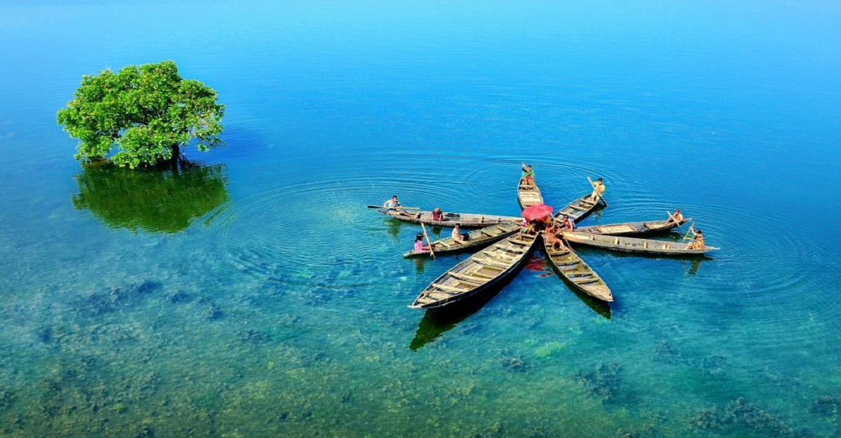
Figure 5: Tanguar Haor (Dhakapost)
This haor is an ideal place for the migratory birds. Every winter about 200 types of migratory birds come to this haor and make their temporary habitat here. Once upon a time zamindars used Pansi boats to hunt birds here. It is also a significant source of fisheries. More than 140 species of fresh water fishes are available here. Among them the notables are Air, Gang Magur, Baim, Tara Baim, Gutum, Gulsha, Tengra, Titna, Garia, Beti, Kakia etc. Hijal (Barringtonia acutangula), Karach (Pongamia pinnata), Gulli, Balua, Ban Tulsi (Ocimum americanum), Nalkhagra (Phragmites karka) and some other important threatened species of freshwater wetland trees are available in this haor.
For more details about the biodiversity of Tanguar Haor follow the following references:
- Biodiversity of Tanguar Haor: A Ramsar Site of Bangladesh Volume I: Wildlife (Amphibians, Reptiles, Birds and Mammals)
- Biodiversity of Tanguar Haor: A Ramsar Site of Bangladesh (Volume II: Flora)
- Biodiversity of Tanguar Haor: A Ramsar Site of Bangladesh (Volume III: Fish)
- A review of fish diversity, decline drivers, and management of the Tanguar Haor ecosystem: A globally recognized Ramsar site in Bangladesh
- Assessment of aquatic natural resources in the Tanguar haor at Sunamgonj, Bangladesh
References
- Alam ABMS, Chowdhury MSM and Sobhan I 2012 Biodiversity of Tanguar Haor: A Ramsar Site of Bangladesh Volume I: Wildlife, IUCN Bangladesh, Dhaka, Bangladesh, Pp. xi+234. ISBN No: 978-984-33-5057-2
- Alam ABMS, Badhon MK and Sarker MW 2015 Biodiversity of Tanguar Haor: A Ramsar Site of Bangladesh Volume III: Fish. IUCN, International Union for Conservation of Nature, Bangladesh Country Office, Dhaka, Bangladesh, pp xii+216. ISBN No: 978-984-33-9005-9
- Bangladesh Haor and Wetland Development Board (2012) Master plan of haor area
- Hossain MS, Islam MS, Mondal P, Hoq ME (2012) Assessment of aquatic natural resources in the Tanguar haor at Sunamgonj, Bangladesh. Bangladesh J. Fish. Res, 15(16), 81-92
- Iqbal MM, Nasren SHAMIMA, Mamun MAA, Hossain MM (2015) Fish assemblage including threatened species in Hakaluki Haor, Sylhet Bangladesh. Journal of agriculture in the topics, 30, 233-246
- Shahidullah AKM, Haque CE (2016) Social entrepreneurship by community-based organizations: innovations and learning through partnerships. Social enterprise-context-dependent dynamics in a global perspective, 79-101
- Sobhan I, Alam ABMS and Chowdhury MSM 2012 Biodiversity of Tanguar Haor: A Ramsar Site of Bangladesh, Volume II: Flora. IUCN Bangladesh Country Office, Dhaka, Bangladesh, Pp. xii+236. ISBN No: 978-984-33-2973-8
- Sultana MA, Pandit D, Barman SK, Tikadar KK, Tasnim N, Fagun IA, Kunda M (2022). A review of fish diversity, decline drivers, and management of the Tanguar Haor ecosystem: A globally recognized Ramsar site in Bangladesh. Heliyon, 8(11)
- Suvra KIJ (2021) Haor Regions-Importance, Problems, Strategy and Future Development. J. Econ. Financ, 12, 35-48